Wee Notes & Breaking News
These are William’s notes and comments as the year progresses.
BIG Data for a Small Country
Last week, we had meetings with a firm who carry out drone surveys. I may have mentioned previously that we in Terrenus use available LiDAR data in many parts of our work. This ‘Light Detection and Ranging’ type of data is essential for all of the detailed flood risk assessments that we carry out - providing a key part of the model inputs. Good quality information is available from Government - Scottish Remote Sensing Portal, at least in the Central Belt, however, in many other parts of the country, the data is patchy and we are currently investigating commissioning our own surveys to improve our hydraulic models.
A good way of looking at this type of LiDAR data is to login to the SEPA Flood Map. There you will see (below) that the fluvial risk analysis is more ‘blocky’ than the surface water risk analysis, due to the SEPA surface water modelling being more recent than the fluvial modelling. In both cases however, the SEPA models are a compromise which (amongst other reasons) is why you cannot depend on them for Planning purposes. Any bespoke consultants model will (or should) use refined datasets and more detailed knowledge of the site in order to provide a much better understanding of flood risk for a particular site.
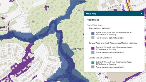
The upshot is that, if you want or need to challenge the SEPA data (as you often do for Planning approval) you will need a more accurate model that SEPA provides. At Terrenus we take pride in doing just that.
Settlement or Subsidence?
Our man in the south, George Shepherd, will take you to task if you get these two terms confused. In land development settlement is a normal function of the soil being compressed (via raised pore water pressure leading to the reduction in soil water content) when a load is applied. Such loads could be an embankment or a building or any other load. The settlement curve is well understood in geo-technics with the initial days showing the fastest settlement and the whole thing tending towards zero over time. Currently, we have sites in the west of Scotland where we are monitoring settlement over time following large scale earthworks over soft Clyde Alluvial soils. We know the area well and have been able to resolve the complex factors involved in the calculations, modelling and monitoring for each of a number of large sites successfully. The key is consistent attention with George being master of the modelling in this case.
Subsidence is a different animal where the land sinks due to some form of underground void or instability. In the central belt of Scotland, this often entails historic mining and in such cases our Alex Muir is the go-to man. Alex is a dab hand at interpreting historic mine abandonment plans and locating old mine shafts. All of these problems can be resolved with sound engineering solutions and, if you do this right, you can turn an economically marginal site into a viable proposition.
Site Safety
We have just finished our weekly Health & Safety meeting at Terrenus - a feature that involves the whole company and where we discuss how we stay safe and well during our work. This week our discussions went from safety around site investigation trial pits and the dangers of entering pits which could collapse through to being generally aware of our surroundings (last week one member of staff banged his head on a sign after plugging his car into a charger - the event was duly logged as an incident).
The discussions brought to my mind the balance between policy, bureaucracy and what we could call general common sense. Actually, I am not sure that there is such a thing as common sense, rather it is a generally behaviour pattern earned by learning and attention to detail. Drill down into this matter and we find that good behaviour is impacted by everything from being tired to eating well and from being upset to being complacent. This is why we must be particularly careful with younger members of staff through the correct use of bureaucracy and our mentoring system. Vigilance is always important.
Stay safe out there everyone.
Hard Hat Talks
Morning all,
I have known Kenneth Martin of Block Architects over many years and more recently we have shared nearby office spaces in the same building. Over the years Kenneth has pushed development communication and the industry profile in general on a variety of platforms and now Kenneth has come up with ‘The Hard Hat Talks’ podcasts which he describes as ‘No More Fluff – Just Honest Conversations About Our Industry’ with Kenneth himself as the host.
Kenneth dropped in to our office last week and asked me to consider a slot on flood risk and, in particular, the impact of the new SEPA surface water and small watercourses flood maps on land development. Keen to promote useful communication I readily agreed and hope to come back to you all shortly with an update.
Spring is Sprung
Well the Spring equinox is past, the clocks have gone forward and Easter is just round the corner. Daffodils are out and the sunshine is becoming warmer. For those who are affected by seasonal adjustment disorder the year can finally begin. My wife suggested at the weekend that we should make our New Year resolutions now rather than in January since it is much easier to look forward at this time of year than it is in the dark days of Winter. - what would yours be if asked now?
Whatever is the case I recommend that, if you can, you take a break and take a moment to enjoy the new growth, the warmth and the extra daylight.
